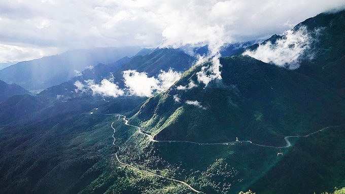
O Quy Ho Pass is an important traffic route connecting the two northern mountainous provinces of Lai Chau and Lao Cai; moreover, it is also a tourist attraction thanks to the majestic and green beauty of northwest nature.
O Quy Ho Pass is an important traffic route connecting the two northern mountainous provinces of Lai Chau and Lao Cai; moreover, it is also a tourist attraction thanks to the majestic and green beauty of northwest nature.
 |
| The beauty of O Quy Ho Pass. (Photo: ND) |
O Quy Ho Pass, which is also known as Hoang Lien, is located on National Highway 4D. Two-thirds of the pass belongs to Tam Duong District in Lai Chau Province and the rest is located in Sapa Town of Lao Cai. At an altitude of about 2,000 m above sea level and with a length of nearly 50 kilometres, the pass is considered the "king" of the passes in Vietnam and the destination for many travellers to conquer.
There is a legend attributed to the indigenous H’Mong people about the origin of the pass's name. The legend said that once a fairy and a woodcutter loved together but could not live together. The man was turned into a black turtle under a waterfall on the top of the pass and the fairy missed her lover so turned into a bird that had been flying over the pass and crying out: “O Quy Ho! O Quy Ho!”. This romantic and tragic love story motif is quite common in many cultures, so people also seem to become more emotional when standing on the top of the windy O Quy Ho Pass and watching the pure sae and clouds embracing the deep blue mountains.
The highest point of the pass is called "heaven's gate" that is covered with clouds almost all year round. It seems that people can touch the soft clouds. The weather on either side of the "heaven gate" will offer a unique experience to visitors thanks to its characteristics of altitude and wind direction.
In the middle of summer, when the sun is shining brightly and the sky is clear on the Lai Chau side, people can clearly see the roads winding around the mountainsides, beside the bottomless abyss. Meanwhile, the Lao Cai side is foggy with rolling mountains hidden behind floating clouds. In winter, Sapa side is always colder, and even covered with snow and ice, while Tam Duong’s part is warm to slightly cold.
Those who are eager to travelling can ride a motorbike through the pass to feel the most dangerous and winding bends in the north. The road that used to be a "nightmare" for long-distance drivers has been repaired and upgraded to become an ideal place to admire the hills, corn fields, terraced fields sparkling in the sun, or the villages in the back of the sky.
(Source:Nhan Dan)


