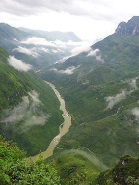
Those conquering the Ma Pi Leng mount in the northern upland province of Ha Giang shall be amazed by a river like a silky fillet in fog as it brings them a pleasant feeling of a naturally romantic masterpiece. That river is called Nho Que.
 |
| Nho Que River is seen from Ma Pi Leng Pass in Ha Giang Province |
Those conquering the Ma Pi Leng mount in the northern upland province of Ha Giang shall be amazed by a river like a silky fillet in fog as it brings them a pleasant feeling of a naturally romantic masterpiece. That river is called Nho Que.
Nho Que River flows from Nghiem Son Mountain at the height of 1,500 meters height. It is about 46 kilometers long, with its upstream stretching more than five kilometers in the border between Vietnam and China and the rest flowing through Ha Giang and Cao Bang provinces. Running through rugged rocks, it creates a waterfall in the middle of the valley.
The river flows through Tu San canyon and Ma Pi Leng Pass of Meo Vac District, about 15 kilometers from Lung Cu Peak.
Having a narrow path with a limestone mountain on one side and deep valleys on the other side, the terrain makes people scary if they look down at the abyss. However, visitors can enjoy a splendid view of terraced rice fields on the mountainside, ethnic villages scattered in the valleys and Nho Que River.
(Source:SGT)


