
After lashing the Philippines, Super Typhoon Haiyan is heading for central Vietnam with maximum winds of over 220 kph. It is likely to hit several provinces Sunday morning, the National Center for Hydro-Meteorological Forecasting (NCHMF) reported.
After lashing the Philippines, Super Typhoon Haiyan is heading for central Vietnam with maximum winds of over 220 kph. It is likely to hit several provinces Sunday morning, the National Center for Hydro-Meteorological Forecasting (NCHMF) reported.
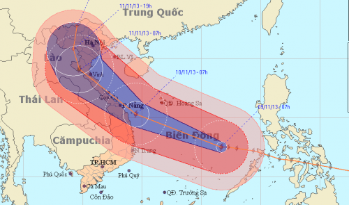 |
| The expected path of Super Typhoon Haiyan |
International experts said that Haiyan is perhaps the strongest storm in human history. According to the US-based Weather Underground Organization (WUO), as it approached the Philippines the typhoon packed sustained winds of 315 kph and gusts of 380 kph, stronger than any storm ever observed.
The extremely powerful typhoon killed at least 100 people in the central Philippines before entering the East Sea last night, Reuters reported.
At 4 am ICT today, November 9, the typhoon was centered at 12.5 degrees latitude north and 117.3 degrees longitude east, 360 km east-northeast of Song Tu Tay Island, part of the Truong Sa (Spratly) archipelago, with winds as high as 167-201 kph, together with gusts of over 220 kph, NCHMF reported.
Due to the super typhoon, from this morning the central East Sea, including the areas around Truong Sa and Hoang Sa (Paracel), will experience rough seas and winds as strong as 89-133 kph, which will increase to 201 kph around the eye, together with gusts of over 220 kph.
Haiyan is moving between west and west-northwest at about 30-35 kph, and at 4 am Saturday it will be located off of Thua Thien-Hue and Binh Dinh provinces, with winds of 150-183 kph and gusts as strong as 220 kph.
According to a report issued at 5:30 am by the NCHMF, the typhoon may later change its direction to between west-northwest and northwest, and first make landfall in the coastal region running from Quang Ngai to Thua Thien-Hue provinces at about 4 am Sunday.
The storm will then sweep through central Vietnam at about 30 kph, impacting several provinces, including Quang Tri and Ha Tinh.
However, according to the center's report issued at 11:30 am, Haiyan will not hit the Quang Ngai-Thua Thien-Hue region but when coming near Quang Ngai's Ly Son Island it will change its direction to run along off the coastal central region and will strike the Ha Tinh-Quang Binh region later.
Meteorological agencies in Hong Kong, China and Taiwan also forecast that the typhoon will sweep through north central provinces from Quang Binh to Thanh Hoa.
At 4 am on November 11, the typhoon will be centered in the mountainous areas of the north central region, with weaker winds, at 75-102 kph, together with gusts of 133 kph, according to NCHMF.
The storm’s movement will then slow to 15 kph and weaken into a tropical depression.
Yesterday Prime Minister Nguyen Tan Dung chaired an online meeting with local authorities in the region running from Thanh Hoa to Ca Mau Provinces, asking them to take measures to cope with the storm.
All possible forces and efforts must be made to ensure people’s safety while minimizing property damage, he said.
The National Committee for Search and Rescue last night reported that more than 450,000 soldiers and militia, and over 5,400 means of transport, including 12 planes, 356 ships, and 2,680 trucks, have been mobilized to deal with the super typhoon’s impact.
(Source:TTNews)
