
Dr Trinh Quang Toan from the UC Davis University has introduced a technology that calculates precipitation, meteorology, hydrology and groundwater for real-time natural calamity forecasting in Vietnam.
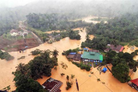 |
Dr Trinh Quang Toan from the UC Davis University has introduced a technology that calculates precipitation, meteorology, hydrology and groundwater for real-time natural calamity forecasting in Vietnam.
The forecasting technology combines artificial intelligence, satellite imagery and radar, and together with a computational model, can restore data about flow and water level.
This would help Vietnam take the initiative in capturing data about the Red, Thai Binh and Mekong Rivers’ basins, rather than relying entirely on China. The materials help scientists calculate the possible impact of Chinese water reservoirs on Vietnam.
The technology also monitors the water level of Chinese reservoirs in the upper course through satellite imagery taken daily or hourly. Based on the data, Vietnam will be able to give timely warnings so as to avoid casualties and damages.
According to Dao Trong Tu from the Vietnam River Network, former secretary general of the Vietnam Mekong Commission, forecasting rains and collecting hydrological data by using satellite imagery has been used in many countries.
Vietnam is among the countries utilizing the method. The accuracy and reliability of the meteorological forecasting model is relatively high.
The difficulty in flood forecasting lies in the fact that there are hundreds of Chinese reservoirs, and if Vietnam has no information about the operating procedures, the designs and the terrains of hundreds of dams and reservoirs, it will not be able to calculate the volume of water on streams and the time when floods may occur.
“It is necessary to understand the operating mechanism of dams and reservoirs to give forecasts for the lower course: how much water is stored in reservoirs, when reservoirs discharge water, and how much water to discharge,” he explained.
“Only when you know the information will you be able to forecast the possible impacts of the current on the lower course,” he said. “However, this is a problem which still cannot be settled.”
“It is very difficult to capture information about reservoirs through satellite images. It is impossible to rely on satellite images only to consider water levels at reservoirs and give warnings,” he said.
“And how can we get satellite images? In fact, we have to pay for the data,” he said.
Emphasizing that Vietnam has been using modern technology in hydrometeorology, Tu said there is a monitoring system on the Red River and a monitoring station in the upper course.
Vu Trong Hong, former Minister of Agriculture and Rural Development, also thinks that collecting data independently is not feasible because it not only depends on technology, but on political and diplomatic factors.
(Source: VNN)


