
Backpacking the length and breadth of Vietnam, lensman Dang Van Hai captures the dizzying beauty of both rural and urban landscapes with aerial shots.
Backpacking the length and breadth of Vietnam, lensman Dang Van Hai captures the dizzying beauty of both rural and urban landscapes with aerial shots.
 |
| Ethnic minority women walk through perfectly chiseled terraced rice fields in Mu Cang Chai as the crop yellows and gets ready for the harvest season, October 2020. Mu Cang Chai, a rural district in Yen Bai Province, is around seven hours' drive from Hanoi. The town sits at 1,000m above sea level at the foot of Hoang Lien Son Mountain Range. Its rice terrace fields stretch across 2,200 ha of the mountainside. |
 |
| Red and orange tiled buildings seem to peep out of passing clouds in Sa Pa, a tourist town in Lao Cai Province on an early morning in November 2020. |
 |
| The Son River in Quang Binh Province, which literally means Red River as its water turns red during the flooding season, flows blue through undulating hills and mountains in July 2020. The upstream section of this river runs 7,729 m underground through limestone mountains in the UNESCO heritage site, Phong Nha-Ke Bang National Park, home to over 300 caves and grottoes that date back some 400 million years. |
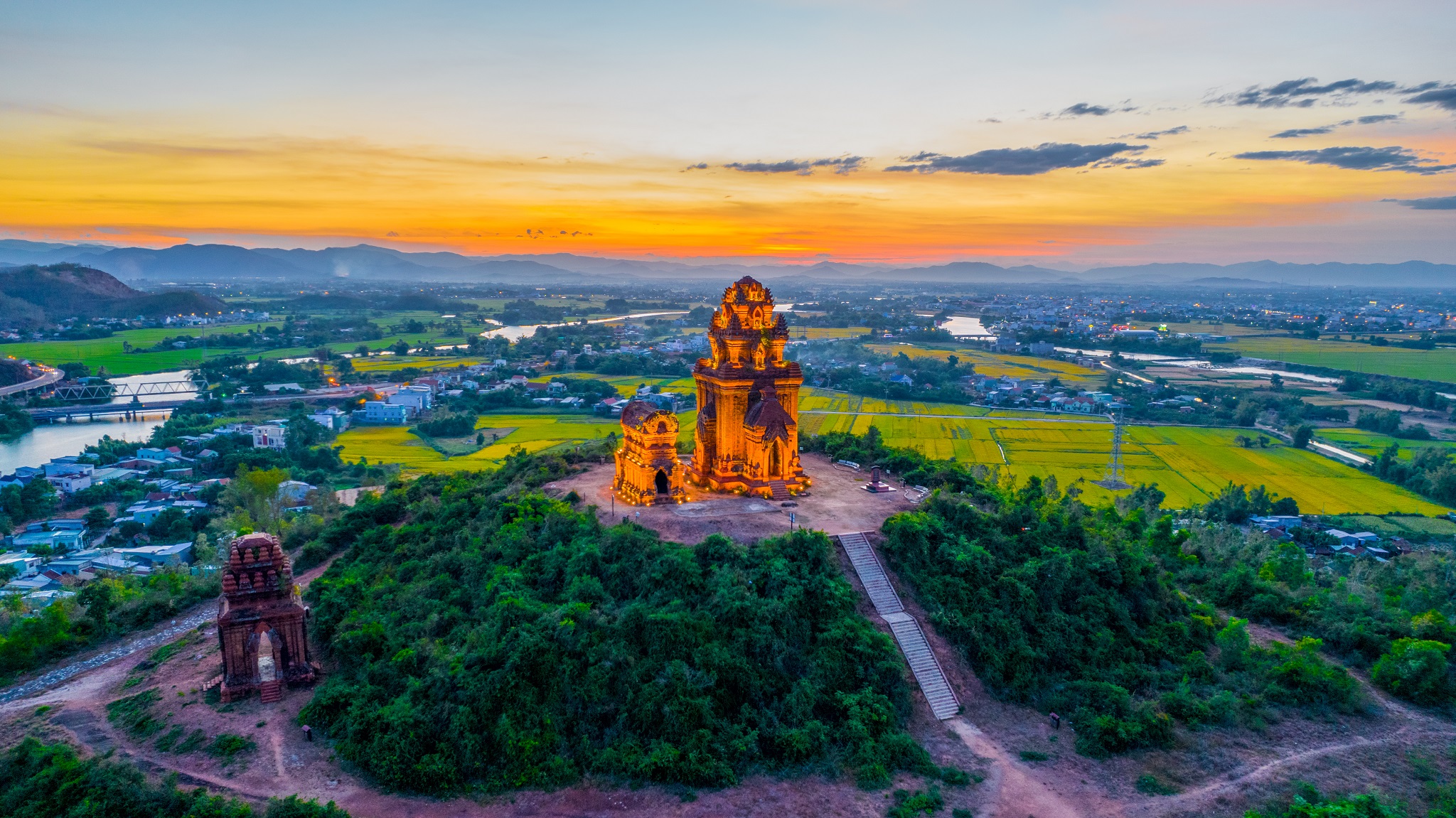 |
| The Banh It Towers, built during the reign of the Cham kings in the 10th century, glows a golden red in Binh Dinh Province. The complex consists of four towers, the main one being around 22 m tall. It gets its local name from a triangular glutinous rice cake filled with green bean paste and meat made that is popular in the central province. Once the political and cultural hub of the ancient Champa Kingdom, Binh Dinh is home to many vestiges of the ancient culture. |
 |
| Another glow in the dark shot captures a fisherman casting a nest from his coracle to harvest seafood hidden under layers of green seaweed in Hon Kho Islet, Nhon Hai District, around 30 kilometers from downtown Quy Nhon. The photo was taken in May this year. This seaweed, called Sargassum, reproduces and develops naturally in the Binh Chau sea. It grows in coral reefs and underwater rocks and emerges from the water surface once fully grown, resembling an underwater forest. The seaweed harvest season begins in April and ends in June. |
 |
| Ro cho, a type of fishing net popular in the region, stand silently in Thi Nai Lagoon, Binh Dinh Province, as a boat creates an arrowhead in its waters this August. The ro cho is supported by four long bamboo poles with a sagging fishing net in the middle shaped like a pan. Fishermen use bamboo sticks to sweep and push trapped fish into the navel and later to one side of the net for harvesting. Thi Nai hosts many species of aquatic products with high economic value like oysters and crabs. |
 |
| From above the clouds, the En Waterfall in K'bang District, Gia Lai Province, marks the origin of the Con River. Hai captured this spectacular view in 2017 during a trek through the forest. En, 54 m tall, is considered the highest, most beautiful and most mighty waterfall in the Central Highlands. During the dry season, it is 20-30 m wide. Its spray creates plenty of rainbows. |
 |
| Large areas of the Ta Dung Lake covered by white clouds. This lake in Dak Nong Province is often referred to as the Ha Long Bay of the Central Highlands. This shot was taken in January 2020. With a 20,000 ha water surface and more than 36 islands, the lake and its surrounding park serves as the natural habitat of many bird species. |
 |
| Hai and his friends trek the Ta Nang-Phan Dung route that runs through the three provinces of Lam Dong, Ninh Thuan and Binh Thuan, early October 2020. |
(Source: VNExpress)


