Dong Nai is one of the few provinces in Vietnam blessed with the country's longest inland river. The Dong Nai River, with its broad water surface and gentle flow winding like a silk ribbon, not only creates a distinctive landscape but also holds significant potential for economic and urban growth.
Leveraging this “golden” advantage to form a chain of ecological urban areas aligns with the global trend of sustainable development, while also asserting Dong Nai’s unique urban identity.
PAVING THE WAY FOR RIVERFRONT URBAN DEVELOPMENT
Stretching over 580 kilometers, the Dong Nai River is the longest inland river in Vietnam, with approximately 260 kilometers of its length flowing through the province. Characterised by its calm current and broad, deep bed, the Dong Nai River has long brought significant benefits to the socio-economic development of southern provinces, from abundant water for daily use and production to fertile alluvial soil that supports agriculture and maintains forest ecosystems. However, another “privilege” the river offers the province—its space for riverfront urban development—has yet to be properly tapped.
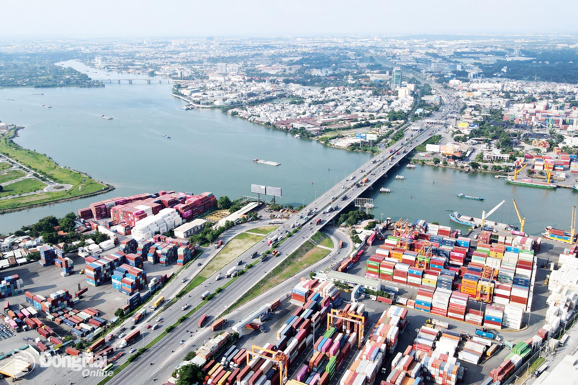 |
| The Dong Nai River section, which runs through Dong Nai Province, offers immense economic, ecological, cultural, and scenic values, forming a foundation for sustainable urban growth. Photo courtesy of contributor |
According to Member of Provincial Party Committee and Vice Chairman of Dong Nai People’s Committee Ho Van Ha, amidst its dynamic industrial land and rapidly urbanizing areas, Dong Nai province still possesses a rare landscape feature with a river encircling the province, particularly in urban or planned urban areas such as Bien Hoa, Long Thanh, and Nhon Trach. Yet, to date, Dong Nai has not developed a riverside urban area— one that could provide community enjoyment, enrich the local landscape, and affirm the province’s distinct character.
In reality, several major urban projects have been launched along the riverbanks, including Kim Quy Island (Bien Hoa Ward), Aqua City (Long Hung Ward), KN Bien Hoa (Phuoc Tan Ward), Amata City (An Phuoc Commune), and Dai Phuoc Ecological Urban Area (Dai Phuoc Commune). Most of these projects are still under development. Once completed and operational, they will expand the province’s riverfront urban space, creating a chain of modern waterfront urban areas that are on par with those across the river in Ho Chi Minh City.
Under the provincial planning scheme approved by the Prime Minister, the development of a riverside urban chain is defined as the core of the southern urban–service–industrial region, linked to the Bien Hoa–Long Thanh–Nhon Trach growth corridor. In the revised provincial planning (following the provincial merger), the riverside economic corridor remains one of three strategic development corridors, focusing on harnessing the advantage of waterfront landscape to develop ecological urban areas, tourism, and high-end services.
Contributing comments to the provincial planning (under adjustment), experts from the Ho Chi Minh City Urban Planning Institute have remarked that Dong Nai possesses an exceptional diversity of terrain and ecosystems, from rivers, lakes, and waterfalls to forests and mountains. This diversity provides a strong foundation for establishing growth axes aligned with the natural environment, moving toward a multi-centered spatial model that integrates urban, industrial, rural, and ecological zones. The experts also emphasised that riverside urban development must ensure a balance expanding construction space and protecting hydrological systems, mitigating natural disasters, adapting to climate change, and conserving biodiversity.
CREATING GREEN LIVING SPACES
In the context of increasingly rapid urbanization, developing urban chains along rivers and lakes is an inevitable trend. Such developments not only make full use of land and natural landscapes but also help relieve pressure on central urban areas, offering residents more sustainable and greener living spaces.
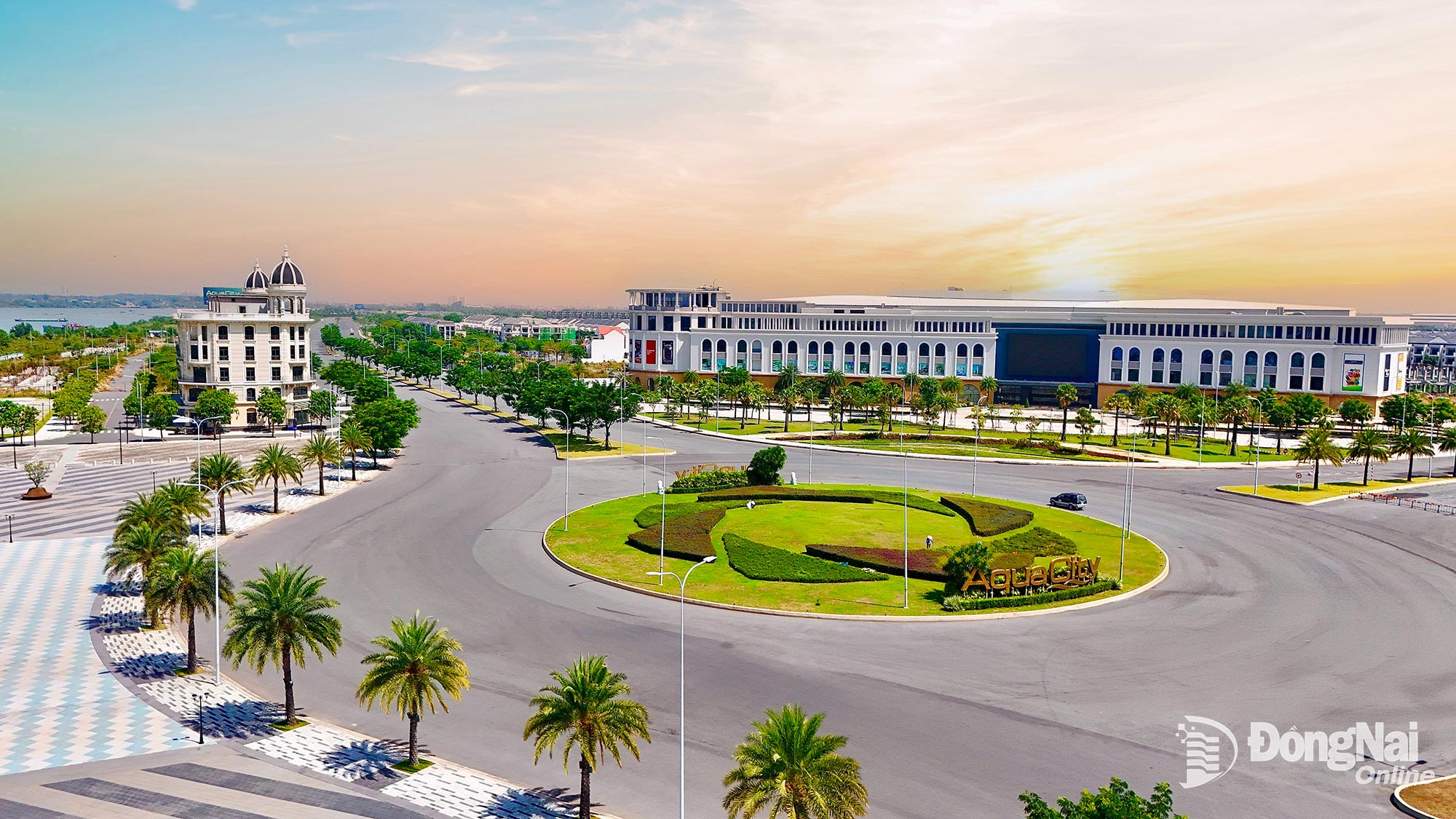 |
| A riverside eco-urban project in Long Hung Ward, Dong Nai Province, is taking shape. Photo courtesy of contributor |
A prime example of this is Dong Nai’s ongoing conversion of the Bien Hoa 1 Industrial Zone, the oldest industrial park in the country, into a riverside urban, commercial, and service hub.
According to Vice Chairman of Dong Nai People's Committee Ho Van Ha, this project represents not only an economic and urban milestone but also a significant step in reshaping the riverside landscape. Upon completion, this area will become a modern, environmentally friendly riverside urban area. It also marks a concrete move toward reducing urban emissions in pursuit of the net-zero target by 2050, creating high-quality living spaces for communities and giving Dong Nai a facelift.
Dong Nai is currently implementing several infrastructure projects that directly connect the province with Ho Chi Minh City. The completion of Ring Roads 3 and 4 along with 5 railway routes and three river-crossing bridges, will open up new opportunities, shortening travel times to the nation’s largest economic hub.
To harmonise the goals of urban growth and environmental protection, the province has announced a water resource protection corridor and is rolling out numerous riverside road and ecological park projects. It is also planning urban wastewater and drainage systems. For riverside urban zones, authorities have mandated strict adherence to approved plans, maintaining low construction density while allocating large areas for green spaces, water surfaces, and public spaces.
Dang Van Thanh, Chairman of TTC Group and the developer in the Tan Van Islet urban project (Bien Hoa Ward), stated that with the advantage of a surrounding river, the project is being developed as a smart ecological model, featuring low construction density, a high proportion of green coverage, integrated amenities, and modern management technology, including centralized wastewater treatment.
Meanwhile, a representative of Novaland Group, the investor of a riverside urban project in Long Hung Ward, said that the project aims to establish a standard ecological living environment, with more than 70% of its area reserved for greenery, infrastructure, and public utilities. With 32 kilometers of natural riverbanks encircling the site, the project also includes a marina to support the development of green transport and waterway tourism.
Today, many major cities around the world have successfully developed the riverside and coastal urban models to create sustainable living spaces. This approach not only effectively leverages landscape values, promotes tourism and the service economy, but also contributes to shaping local identity. With its strategic vision outlined in the provincial master planning, the coordinated implementation of infrastructure projects that both connect and protect water resources, and a priority given to green investment attraction, Dong Nai is well-equipped to become a pioneering locality in developing riverside ecological urban areas.
By Hoang Loc – Translated by My Le, Thu Ha


Thông tin bạn đọc
Đóng Lưu thông tin