The Ho Chi Minh Highway, which is being expanded, stretches from the northern mountain province of Cao Bang to the southernmost province of Ca Mau. The 3,000km project will be completed in 2020, of which nearly 450 km of road will meet highway standards.
The Ho Chi Minh Highway, which is being expanded, stretches from the northern mountain province of Cao Bang to the southernmost province of Ca Mau. The 3,000km project will be completed in 2020, of which nearly 450 km of road will meet highway standards.
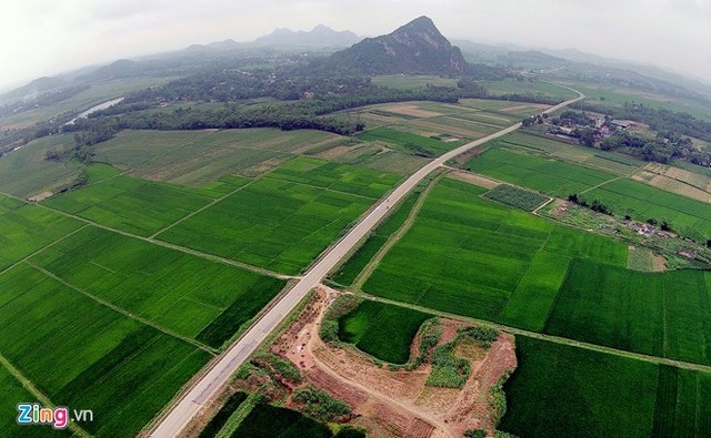
 The expanded Ho Chi Minh highway will run from the south to the north, with a total length of over 3,000 km (from Ca Mau to Pac Bo, Cao Bang) and it will be the second North-South Highway of Vietnam. In the photo: the section near the town of Xuan Mai (Hanoi).  The road project also includes upgrading and expansion of several provincial and national roads as well as new sections. In the picture: the section passing the town of Mieu Mon, in Chuong My District, Hanoi.  Only the Ho Chi Minh Highway uses yellow lines to separate lanes.  In 1959, President Ho Chi Minh decided to establish the strategic road to support South Vietnam and neighboring countries as Laos and Cambodia. The road was later named the Ho Chi Minh Trail. Photo: a road section in Lac Son District, Hoa Binh Province.  During the war, the Ho Chi Minh Trail began from Nghe An (Tan Ky town, Tan Ky district, marked by milestone 0) and extended to the southern tip of Ca Mau. It was then upgraded and expanded to the town of Xuan Mai, Hanoi.  The upgrade and expansion in Phase 1 began in 2000, with two lanes, and finished in 2008.  Phase 2 commenced in 2007 and will be completed in 2015, with two lanes, running from Pac Bo (Cao Bang) to Dat Mui (Ca Mau). A number of big bridges will be completed in 2020. In the photo: the section running through the Cuc Phuong National Park, Hoa Binh Province.  Phase 3 (2012-2020) will focus on construction of a 445 km highway-standard road, including sections from Doan Hung (Phu Tho Province) to Ben Market (Hoa Binh Province), Cam Lo (Quang Tri Province) to Tuy Loan (Danang), and My An (Dong Thap) to Rach Soi (Kien Giang).  After 2020, the remaining sections of the road will be built. In the picture: the section through Cam Thuy District, Thanh Hoa Province.  The 3,183 km road will run through 28 provinces and cities after completion.  In the picture: the Lam Kinh Bridge spanning the Chu River in Tho Xuan District (Thanh Hoa Province).  Total investment in phase 1 is more than VND13,300 billion, more than VND27,700 billion in Phase 2 and VND273,000 billion in Phase 3 (not including VND23,000 billion for 133 km of Ho Chi Minh Highway that coincides with other projects). |
(Source: VNN)


